
Επίσκεψη στο Korjakskij
Χρήσιμες πληροφορίες για το κέντρο που θα σας βοηθήσουν να προγραμματίσετε το ταξίδι σας στο %{resort_name}
- Εναρξη σεζόν—
- Λήξη Σεζόν—
- Διαμονή—
- Εστιατόρια | Μπαρ— | —
- Κοντινότερο Αεροδρόμιο Elizovo
- Κοντινότερο τρένο —
- Iστοσελίδα
- Τηλέφωνο εξυπηρέτησης—
Παροχές στο Korjakskij
Η έκταση στο Korjakskij περιλαμβάνει:
- HalfpipesN
- ΠάρκαNo
- Cross Country18.0 km
- Ενοικίαση Εξοπλισμού Σκι—
Πώς είναι στο χιονοδρομικό κέντρο Korjakskij;
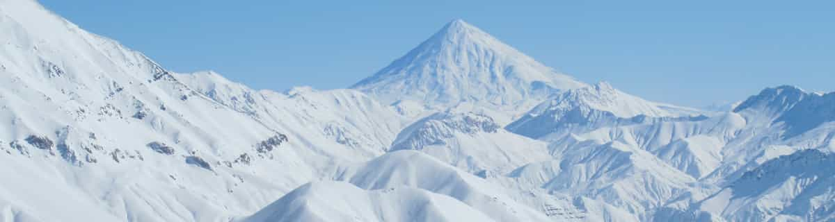
Korjakskij is the highest volcano of the volcanic range (Aag, Arik, Korjakskij, Avachinskaja, Uglovaja Kozelskij) situated 31km north-east from Petropavlovsk-Kamchatskij. Korjakskij is a typical stratovolcano with the regular ribbonated conus. There are no ski-lifts on the Korjaksij's slopes. In lower part you can skin up on skis with AT bindings, whereas on the upper part, crampons and ice-axe are needed. It is an area for advanced skiers only. There are several routes to the valley between volcanos Korjakskij and Avachinskaja, but other routes are to the Nalychevo valley or at the other side of the volcano. These extra routes are not used so often as the access is quite long. All routes are quite hard. Another possibility is to use a helicopter to take you up the summit but only in really nice weather (there is mostly very strong wind on the summit). Petropavlovsk-Kamchatskij - Korjakskij is about 31km. Three possible routes to the Korjakskij volcano. Route 4 is classical on the south-east rib, route 5 is through the main coloir, and route 6 is the fastest - it is often used for descending. All these routes started on the summit and finish at cottage camp, vertical difference is about 2600m. Nice route for cross-country skiing is in the valley of Sucha recka river - 18km. Other activities including snowmobiling, paragliding, etc.
Εξερευνήστε τον χάρτη τοποθεσίας του Korjakskij
Διαδραστικός χάρτης μονοπατιών και πίστας Korjakskij. Προβάλετε την πίστα και τα μονοπάτια, καθώς και τα γύρω εδάφη και ορεινά περιγράμματα για δράση στην εξοχή. Βρείτε και συγκρίνετε κοντινά θέρετρα με κλικ στους δείκτες θέρετρου.

Ποιος είναι ο μήνας με το περισσότερο χιόνι στο κέντρο Korjakskij;
Πώς είναι το χιόνι τώρα στο Korjakskij?
Σύνοψη των συνθηκών χιονιού που ισχύουν αυτήν τη στιγμή στο Korjakskij. Βρείτε περισσότερες πληροφορίες στο Korjakskij σελίδα αναλυτικού δελτίου χιονόπτωσης.
- Κατάσταση πίστας—
- Κατάσταση εκτός πίστας—

| Υψος Χιονιού Κορυφής: | ||
|---|---|---|
| Υψος Χιονιού Βάσης: | ||
Κριτικές επισκεπτών για Korjakskij
Χιονοδρομικά κέντρα κοντά στο Korjakskij
Ανακαλύψτε χιονοδρομικά κέντρα κοντά στο Korjakskij. Κάντε κλικ παρακάτω για να δείτε οδηγούς για χιονοδρομικά κέντρα.
 Nearest