
Επίσκεψη στο Mount Kenya (Kirinyaga)
Χρήσιμες πληροφορίες για το κέντρο που θα σας βοηθήσουν να προγραμματίσετε το ταξίδι σας στο %{resort_name}
- Εναρξη σεζόν—
- Λήξη Σεζόν—
- Διαμονή—
- Εστιατόρια | Μπαρ— | —
- Κοντινότερο Αεροδρόμιο —
- Κοντινότερο τρένο —
- Iστοσελίδα—
- Τηλέφωνο εξυπηρέτησης—
Παροχές στο Mount Kenya (Kirinyaga)
Η έκταση στο Mount Kenya (Kirinyaga) περιλαμβάνει:
- Halfpipes—
- Πάρκα—
- Cross Country—
- Ενοικίαση Εξοπλισμού Σκι—
What's it like at Mount Kenya (Kirinyaga)?
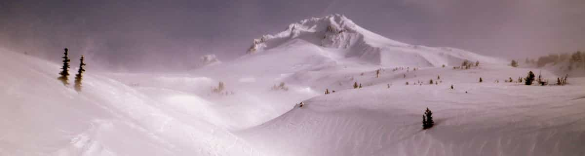
Mount Kenya (Kirinyaga) is the second highest mountain in Africa. Like Mount Kilimanjaro, it is an extinct volcano. It dominates the Central Kenyan highlands, towering just seventy miles north of Nairobi, and ten miles south of the Equator. The mountain was once much higher, but today it is a large dome, roughly 60 miles in diameter, from which rises the steep, eroded remains of its volcanic core. Mount Kenya (Kirinyaga) has twin summits: a pair of rocky snow-capped peaks, Batian (17,057 feet./5199 metres) and Nelion (17,021 feet./5188 metres), separated by a narrow gap and surrounded by an intricate system of peaks and ridges, with many high glaciers. More technically difficult than Kilimanjaro, Mount Kenya (Kirinyaga) offers some of Africa's finest rock and ice climbing. Huts are available along the most common routes, but the more serious routes may require bivouacs. The mountain is heavily forested, and its ecological diversity is one of its primary attractions. A variety of plant life grows on the slopes of Mount Kenya (Kirinyaga), including camphor, cedar, and bamboo. Elephant, rhino, buffalo and leopard roam the surrounding areas.
Εξερευνήστε τον χάρτη τοποθεσίας του Mount Kenya (Kirinyaga)
Διαδραστικός χάρτης μονοπατιών και πίστας Mount Kenya (Kirinyaga). Προβάλετε την πίστα και τα μονοπάτια, καθώς και τα γύρω εδάφη και ορεινά περιγράμματα για δράση στην εξοχή. Βρείτε και συγκρίνετε κοντινά θέρετρα με κλικ στους δείκτες θέρετρου.

Ποιος είναι ο μήνας με το περισσότερο χιόνι στο κέντρο Mount Kenya (Kirinyaga);
Πώς είναι το χιόνι τώρα στο Mount Kenya (Kirinyaga)?
Σύνοψη των συνθηκών χιονιού που ισχύουν αυτήν τη στιγμή στο Mount Kenya (Kirinyaga). Βρείτε περισσότερες πληροφορίες στο Mount Kenya (Kirinyaga) σελίδα αναλυτικού δελτίου χιονόπτωσης.
- Κατάσταση πίστας—
- Κατάσταση εκτός πίστας—

| Υψος Χιονιού Κορυφής: | ||
|---|---|---|
| Υψος Χιονιού Βάσης: | ||
Κριτικές επισκεπτών για Mount Kenya (Kirinyaga)
Χιονοδρομικά κέντρα κοντά στο Mount Kenya (Kirinyaga)
Ανακαλύψτε χιονοδρομικά κέντρα κοντά στο Mount Kenya (Kirinyaga). Κάντε κλικ παρακάτω για να δείτε οδηγούς για χιονοδρομικά κέντρα.
 Afriski Mountain ResortΤελευταία χιονόπτωση: 4.0 cm Thu 02 Jul
 Αναβατήρες: 4
 Πίστες: 23322 km μακριά
 TiffindellΤελευταία χιονόπτωση: 1.0 cm Thu 02 JulΑναβατήρες: 5Πίστες: 23541 km μακριά
 Mount HermonΤελευταία χιονόπτωση: 2.0 cm Mon 04 MayΑναβατήρες: 10Πίστες: —3720 km μακριά
 Pooladkaf Ski ResortΤελευταία χιονόπτωση: 1.0 cm Tue 31 MarΑναβατήρες: 1Πίστες: —3726 km μακριά
 Nearest